The Ladoga polygon is part of a network of carbon monitoring sites, with Ladoga providing data for this north-west region of Russia. It stores large volumes of carbon in soils, approx 208 tC/ha which is the largest volume outside of permafrost affected soil. The region has not had any significant agricultural activity for over 40 years making it diffcult to estimate the impact on the release of greenhouse gases such as carbon dioxide and methane. The scientists summarised the key climatic changes in Russia including temperature, ice / permafrost cover, moisture and drought, but more significantly atmospheric carbon dioxide (CO2), and methane (CH4):
On the territory of Russia, climate warming is approximately 2.5 times
Abakumov et al.,(2024), https://doi.org/10.3390/atmos15030360
more intense than the average for the globe [9]. According to the Report on Climate
Peculiarities on the Territory of Russia for 2022 [10], it was found that the average annualair temperature (deviation from the average for 1991–2020) was +0.87 ◦C. Temperatures above the climatic norm were observed almost throughout the country. At the same time,the highest rate of increase in the mean annual temperature was observed in the Arctic zone +0.8 ◦C/10 years.
There is a stable tendency for the Arctic ice cover to decrease: since the 1980s in the area of the Northern Sea Route, the decrease has amounted to 5–7 times. In the south of the European part of Russia in summer, against the background of rapid
growth of average temperatures, moisture availability is decreasing and the risk of drought is increasing [10]
…the main climate-influencing factor affecting trendsin hydrometeorological parameters is the significant increase in thermodynamically active gases, particularly CO2, in the atmosphere
The region is developing carbon farming – a type of industrialised carbon sequestration, increasing carbon sinks in biomass, organic matter and soils. The main soil in the Ladoga site is podzol (under ash) It has a cool climate, a mix of southern taiga forest growth (after prior agricultural logging) and rock outcrops. Higher precipitation and melting snow cover sustain different wetlands and swamps in some areas.
The scientists wanted to measure the carbon flux of CO2 and CH4 from the soil surfaces. They captured measurements with specialised portable camera systems:
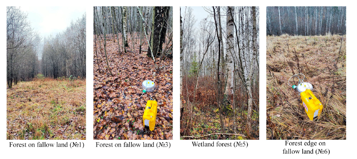
Gas concentrations were recorded in the measuring chambers with a closed loop gas analysis facility. They compared their data with subtropical forest data from China. They noted that quality of soil ecosystems once agricultural activity has stopped includes the quality of wood and plant residues. Ladoga region is close to St Petersburg so the soil could also be influenced by neighbouring anthropogenic activity. They found that wetlands have the lowest levels of emissions for both CO2 and CH4. With the post-agricultural plant communities, it is important to measure these fluxes for wetlands, peatlands as well as drier podzols.
They recommend four policy initiatives to be implemented to protect and increase the levels of carbon in the soils and forest. A stricter regime to prevent illegal logging and encourage sustainable forestry, use of remote sensing to increase measurements over time, promotion of afforestation and reforestation, and restore lost peatlands within the southern taiga.
Abakumov, Evgeny, Maria Makarova, Nina Paramonova, Viktor Ivakhov, Timur Nizamutdinov, and Vyacheslav Polyakov. 2024. “Carbon Fluxes from Soils of “Ladoga” Carbon Monitoring Site Leningrad Region, Russia” Atmosphere 15, no. 3: 360. https://doi.org/10.3390/atmos15030360

